
This page is about railway track diagrams (wiring maps) of the Taiwan Railway Eastern Trunk Line (Yilang Line & North Link Line) from Taipei to Hualien.

台北から花蓮までの、台湾鉄道東部幹線(宜蘭線・北迴線)の線路配線図です。

(Taipei ~ Hualien) Mapas de diagramas de vías Ferrovarias de Línea Troncal del Este(Línea Yilang y Línea de enlace Norte).

這是 臺灣鐵路 東部幹線(宜蘭線 和 北迴線) 從 臺北 到 花蓮 的鐵路圖。
| Table of contents 目次 Eastern trunk line running through eastern Taiwan 台湾東部を走る東部幹線 Línea Troncal del Este que atraviesa el este de Taiwán 東部幹線 貫穿 臺灣東部 The Yilan Line, running through mountainous areas and coastlines 山岳地帯と海岸線を走る、宜蘭線 La Línea Yilan, que atraviesa zonas montañosas y costas 宜蘭線 貫穿 山區 和 海岸線 The North Link Line, running through Taroko National Park 太魯閣国立公園を走る、北廻線 La Línea de enlace Norte, que atraviesa el Parque Nacional Taroko 北迴線,穿越 太魯閣 國家公園 |

Eastern trunk line running through eastern Taiwan
台湾東部を走る東部幹線
Línea Troncal del Este que atraviesa el este de Taiwán
東部幹線 貫穿 臺灣東部
The Eastern Trunk Line is a route of Taiwan Railway that connects Badu Station in the Taipei metropolitan area to Taitung Station. Most trains enter the Western Trunk Line from Badu Station and depart from and arrive at stations in the Taipei metropolitan area.

A unique feature of Taiwan Railways in the Taipei metropolitan area is that most trains do not start or end at Taipei Station. Stations in Taipei City are underground, but Taipei Station only has two platforms and four tracks, so most trains on the Eastern Main Line go to Shulin Station on the west side, while trains on the Western Main Line go to Keelung, Qidu, and Nangang Stations on the east side.

The train runs along the Keelung River. The section from the east side of Nangang Station to Badu, the starting point of the Eastern Main Line, has triple-track.  Trains on the Western Trunk Line run northeast from Badu Station towards Keelung, Taiwan's second largest trading port after Kaohsiung. Meanwhile, trains on the Eastern Trunk Line enter the mountainous section along the Keelung River.

 東部幹線は、台北首都圏の八堵駅から臺東駅までを結ぶ台湾鉄道の路線です。ほとんどの列車が八堵駅から西部幹線に入り、台北首都圏の駅を発着します。
 台北首都圏における台湾鉄道のユニークな点として、ほとんどの列車は台北駅を始発・終着とはしていない点です。台北市内の駅は地下化されていますが、台北駅は2面4線のホームしかないため、東部幹線のほとんどの列車は西側の樹林駅、西部幹線の列車は東側の基隆、七堵、南港駅を発着します。
 列車は基隆河に沿う区間を走行します。南港駅の東側から東部幹線の起点の駅である八堵までの区間は3線化されています。西部幹線の列車は八堵駅から北東へ、高雄に次ぐ台湾第2位の貿易港である基隆へ向けて走行します。一方、東部幹線の列車は基隆河沿いの山岳区間に入ります。

La línea troncal del este es una ruta del ferrocarril de Taiwán que conecta la estación Badu en el área metropolitana de Taipei con la estación Taitung. La mayoría de los trenes ingresan a la línea troncal occidental desde la estación Badu y salen y llegan a estaciones en el área metropolitana de Taipei.

Una característica única de los Ferrocarriles de Taiwán en el área metropolitana de Taipei es que la mayoría de los trenes no comienzan ni terminan en la estación de Taipei. Las estaciones en la ciudad de Taipei son subterráneas, pero la estación de Taipei solo tiene dos andenes y cuatro vías, por lo que la mayoría de los trenes de la línea principal del este van a la estación Shulin en el lado oeste, mientras que los trenes de la línea principal occidental van a Keelung, Qidu y Nangang. Estaciones en el lado este.

El tren recorre el río Keelung. El tramo desde el lado este de la estación Nangang hasta Badu, el punto de partida de la Línea Principal del Este, tiene triple vía.  Los trenes de la línea troncal occidental van al noreste desde la estación Badu hacia Keelung, el segundo puerto comercial más grande de Taiwán después de Kaohsiung. Mientras tanto, los trenes de la línea troncal del este ingresan a la sección montañosa a lo largo del río Keelung.

 東部幹線 是 臺鐵 連接 臺北都會區 八堵站 至 臺東站的路線。火車大部分 從 八堵站 進入 西部幹線,並在 臺北都會區的車站 出發 和 到達。
 臺鐵 在 臺北都會區的 一個獨特之處 是,大部分火車的 起點 或 終點 並不在 臺北站。臺北市的車站 均在地下,但 臺北站 只有 兩個月台 和 四個軌道,因此 東部幹線的 火車 大多 前往西側的 樹林站,而 西部幹線的 火車 前往東側的 基隆、七堵、南港站。
 火車沿著 基隆河 行駛。南港站東側 至 東部幹線起點 八堵 段為 三線鐵路。  西部幹線的 火車 從 八堵站 向東北方向 開往 基隆,是 台灣 僅次於 高雄的 第二大貿易港口。同時,東部幹線火車 進入 基隆河沿岸 山區。


The Yilan Line, running through mountainous areas and coastlines
山岳地帯と海岸線を走る、宜蘭線
La Línea Yilan, que atraviesa zonas montañosas y costas
宜蘭線 貫穿 山區 和 海岸線
The Eastern Trunk Line is divided into three routes depending on the section. These are the Yilan Line, the North Link Line, and the Taitung Line.
The Yilan Line is a line that connects Badu Station to Su'ao Station, and trains run along the mountainous section on the northern half of the line, and along the coastline on the southern half. The entire line is double-tracked and is of high standard, but there are many sharp curves in the mountainous sections.
At Ruifang Station, the non-electrified lines Pingxi Line and Shenao Line diverge. The Pingxi Line is famous for passing through shopping streets and is especially popular with tourists.
From Taipei to the east coast of Taiwan, trains run through mountainous sections with many curves, while road transportation runs on the Beiyi Expressway, a straight route with a series of tunnels. are forced to be at a disadvantage. There is a plan to construct a new line called the Beiyi Straight Railway, and although it was originally planned to be built as a Taiwan Railway line, it is now being proposed to construct it as an extension of the Taiwan High Speed Rail.
東部幹線は、区間により3つの路線に分けられます。それらは、宜蘭線、北迴線、臺東線の3つです。
宜蘭線は八堵駅から蘇澳駅までを結ぶ路線で、列車はこの路線の北半分は山岳区間、南半分は海岸線に沿う区間を走行します。この路線は全線が複線化されていて高規格ですが、山岳区間では急なカーブが多く存在します。
瑞芳駅では非電化路線の平渓線と深澳線が分岐します。平渓線は商店街の中を通り抜けることで有名で、特に観光客に人気の路線です。
台北から台湾の東海岸へは、鉄道がカーブの多い山岳区間を走行するのに対し、道路交通は北宜高速道路というトンネルの連続した直線的なルートを走行するため、列車はマイカーや高速バスに対して劣勢を強いられています。北宜直線鉄道という新しい路線の建設計画があり、当初は台湾鉄道の路線として建設予定でしたが、現在では台湾高速鉄道を延伸する形で建設する方式が提案されています。
La Línea Troncal del Este se divide en tres rutas según el tramo. Estas son la Línea Yilan, la Línea de enlace Norte y la Línea Taitung.
La línea Yilan es una línea que conecta la estación Badu con la estación Su'ao, y los trenes circulan a lo largo de la sección montañosa en la mitad norte de la línea y a lo largo de la costa en la mitad sur. Toda la línea es de doble vía y de alto nivel, pero hay muchas curvas cerradas en los tramos montañosos.
En la estación Ruifang, las líneas no electrificadas Línea Pingxi y Línea Shenao divergen. La línea Pingxi es famosa por pasar por calles comerciales y es especialmente popular entre los turistas.
Desde Taipei hasta la costa este de Taiwán, los trenes discurren por tramos montañosos con muchas curvas, mientras que el transporte por carretera discurre por la autopista Beiyi, una ruta recta con una serie de túneles. se ven obligados a estar en desventaja. Existe un plan para construir una nueva línea llamada Ferrocarril Recto de Beiyi, y aunque originalmente se planeó construirla como una línea ferroviaria de Taiwán, ahora se propone construirla como una extensión del Ferrocarril de Alta Velocidad de Taiwán.
東部幹線 依路段分為 3條線路。它們是 宜蘭線、北迴線 和 臺東線。
宜蘭線 是 連接 八堵站 至 蘇澳站 的鐵路,北半部沿著山區行駛,南半部沿海岸線行駛。全線為複線,標準較高,但山區路段急彎較多。
在瑞芳站,非電氣化線 平溪線 和 深澳線分叉。平溪線 以途經商店街而聞名,尤其受遊客歡迎。
從 臺北 到 臺灣東海岸,火車穿越山區,彎道較多,而 公路交通 則是 北宜高速公路,路線筆直,有一系列隧道。被迫處於劣勢。有計劃興建名為 北宜直線鐵路,雖然原本計劃 作為 台鐵線建設,但現在 卻提議 將其建設 為台灣高鐵的延伸線。


Yilan is the central city in northeastern Taiwan. This region is famous for its heavy rains, and there is a phrase "Zhufenglanyu" which refers to windy Hsinchu and rainy Yilan. The express bus from Taipei to Yilan takes about 40 to 60 minutes, while the train takes about 1 hour and 10 to 20 minutes.

Su'ao is a port city located in the eastern part of Yilan County, and is the terminus of the Yilan Line. Some local(regional) trains enter Su'ao Station, but Su'ao xin(New) Station is the starting station of the North Link Line that continues to Hualien Station, and trains that connect directly to the North Link Line do not pass through Su'ao Station.

 宜蘭は台湾北東部の中心都市です。この地域では多雨であることで有名で、風の強い新竹と雨の強い宜蘭を意味する「竹風蘭雨」という単語があります。台北から宜蘭まで高速バスでは40~60分程度で走行するのに対し、列車は1時間10~20分程度かかります。
 蘇澳は宜蘭県東部に位置する港湾都市で、宜蘭線の終点です。一部の普通列車(区間車)は蘇澳駅に乗り入れますが、蘇澳新駅は花蓮駅まで続く北迴線の始発駅で、北迴線に直通する列車は蘇澳駅を経由しません。

Yilan es la ciudad central del noreste de Taiwán. Esta región es famosa por sus fuertes lluvias, y hay una frase "Zhufenglanyu" que se refiere al ventoso Hsinchu y al lluvioso Yilan. El autobús expreso de Taipei a Yilan tarda entre 40 y 60 minutos, mientras que el tren tarda entre 1 hora y 10 a 20 minutos.

Su'ao es una ciudad portuaria ubicada en la parte oriental del condado de Yilan y es el término de la Línea Yilan. Algunos trenes locales (regionales) ingresan a la estación Su'ao, pero la estación Su'ao xin (nueva) es la estación inicial de la línea North Link que continúa hasta la estación Hualien, y los trenes que conectan directamente con la línea North Link no pasan. Estación Su'ao.

 宜蘭 是 台灣東北部的中心城市。該地區以多雨聞名,有「竹風蘭雨」之說,指多風的 新竹 和 多雨的 宜蘭。從 台北 到 宜蘭的 快車 大約需要 40 至 60 分鐘,而 火車 則大約需要 1 小時 10 至 20 分鐘。
 蘇澳 是位於 宜蘭縣東部的港口城市,也是 宜蘭線的終點。部分普通火車(區間車)進入 蘇澳站,但 蘇澳新站 為 北迴線繼續 至 花蓮站 的始發站,直達 北迴線的火車 不經過 蘇澳站。


The North Link Line, running through Taroko National Park
太魯閣国立公園を走る、北廻線
La Línea de enlace Norte, que atraviesa el Parque Nacional Taroko
北迴線,穿越 太魯閣 國家公園
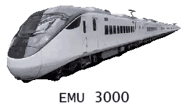
The North Link Line is a 79.2km line that was double-tracked in 2005, running from Su'ao xin(New) Station to Hualien Station. There are many bridges and tunnels in this section, and the New Guanyin Tunnel between Wuta Station and Hanben Station is Taiwan's longest railway tunnel with a total length of 10.307 km.

As of December 2024, only single-track is being operated between Heren and Chongde (construction scheduled to be completed on December 31, 2024) due to landslides.

Until recently, pendulum type TEMU1000 series and TEMU2000 series trains were used for limited express trains on the Eastern Trunk Line, but due to the high manufacturing and operating costs of these trains, in recent years non-pendulum type EMU3000 series trains have become the fastest in operation. The train travels 194.0km from Taipei to Hualien in approximately 2 hours and 30 minutes.

 北廻線は2005年に複線化された、蘇澳新駅から花蓮駅までの79.2kmの路線です。この区間では橋梁やトンネルが多く、武塔駅から漢本駅までの間にある新観音トンネルは全長10.307kmの台湾最長の鉄道トンネルです。
 土砂災害の影響を受け、2024年12月現在、和仁~崇徳間で単線運行が行われています(2024年12月31日に工事完了予定)。
 東部幹線において、最近まで特急列車には振り子式のTEMU1000系やTEMU2000系電車が使用されていましたが、これらの製造・運用コストが高いため、近年では非振り子式のEMU3000系電車が最速達運用に入っています。列車は台北から花蓮までの194.0kmを、約2時間30分で走行します。

La Línea de enlace Norte es una línea de 79,2 kilómetros que tuvo doble vía en 2005 y va desde la estación Su'ao xin (nueva) hasta la estación Hualien. Hay muchos puentes y túneles en esta sección, y el Nuevo Túnel Guanyin entre la estación Wuta y la estación Hanben es el túnel ferroviario más largo de Taiwán con una longitud total de 10,307 km.

En diciembre de 2024, solo se opera una vía única entre Heren y Chongde (la construcción está programada para completarse el 31 de diciembre de 2024) debido a deslizamientos de tierra.

Hasta hace poco, los trenes pendulares de las series TEMU1000 y TEMU2000 se utilizaban para trenes expresos limitados en la Eastern Trunk Line, pero debido a los altos costos de fabricación y operación de estos trenes, en los últimos años los trenes no pendulares de la serie EMU3000 se han convertido en los más rápidos. en funcionamiento. El tren recorre 194,0 km de Taipei a Hualien en aproximadamente 2 horas y 30 minutos.

 北迴線 是 全長79.2公里的鐵路,於2005年開通複線,從 蘇澳新站 至 花蓮站。該路段 橋樑、隧道 較多,其中 武塔站 至 漢本站 之間的 新觀音隧道 是 台灣最長的鐵路隧道,全長10.307公里。
 由於 山體滑坡,截至 2024 年 12 月,在 和仁 和 崇徳 之間 僅 運行 單軌(預計於 2024 年 12 月 31 日竣工)。
 直到最近,擺式TEMU1000系列 和TEMU2000系列 火車 還用於東線幹線的 特急火車,但由於這些火車的 製造 和 運營 成本較高,近年來 非擺式EMU3000系列 火車 已成為最快的火車。 火車 從 臺北 到 花蓮,全程194.0公里,需時約2小時30分鐘。

reference: Taiwan Tabitabi-asia.com
参考:台湾鉄道時刻表 https://taiwan.tabitabi-asia.com/ (Japanese)
The next page is the section from Hualian to Taitung.
次のページは花蓮から台東までの区間です。

To view the other rail route maps in Taiwan, let's click or tap here.
その他の台湾の鉄道線路配線図はこちら
Leave a Reply